barrage zola bimont - vallon marbre - moulin cezanne

mhetpierre
User
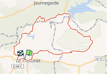

Length
11.9 km

Max alt
384 m

Uphill gradient
417 m
Km-Effort
17.4 km

Min alt
179 m

Downhill gradient
418 m
Boucle
Yes
Creation date :
2018-08-18 15:29:56.917
Updated on :
2018-08-18 15:29:56.917
3h28
Difficulty : Easy

FREE GPS app for hiking
 SityTrail
IGN / Geographical institutes
SityTrail Plus
The world is yours!
About
Trail Walking of 11.9 km to be discovered at Provence-Alpes-Côte d'Azur, Bouches-du-Rhône, Le Tholonet. This trail is proposed by mhetpierre.
Positioning
Country:
France
Region :
Provence-Alpes-Côte d'Azur
Department/Province :
Bouches-du-Rhône
Municipality :
Le Tholonet
Location:
Unknown
Start:(Dec)
Start:(UTM)
702879 ; 4821880 (31T) N.
Comments